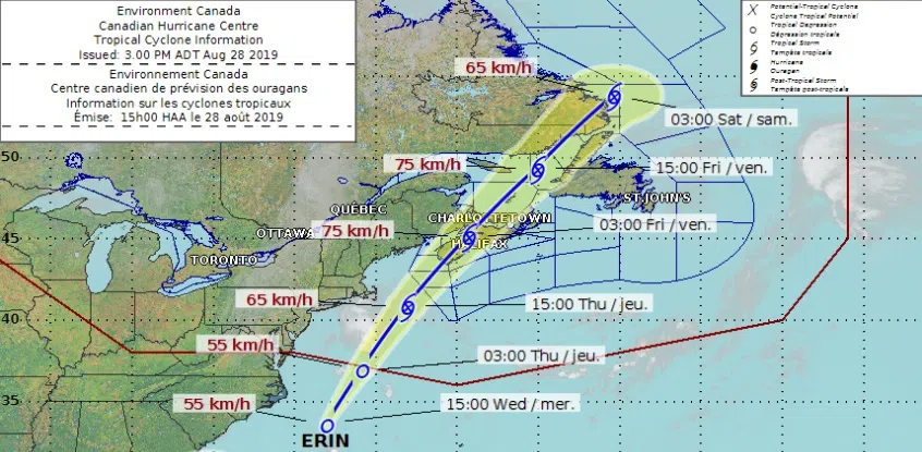
Rain will likely be the biggest impact when what is now tropical depression Erin begins to affect southern New Brunswick.
The Canadian Hurricane Centre says the storm is tracking northeastward toward the Maritimes.
Erin is expected to transition to a post-tropical cyclone well before it reaches southwestern Nova Scotia late Thursday, says Linda Libby, a meteorologist with Environment Canada.
“It means it still has some tropical aspects to it, but its organization is no longer what we see in the tropics where we see a lot of symmetry in terms of where rain falls and how winds are organized,” said Libby.
But forecasters say Erin is still expected to bring lots of rain and strong, gusty winds to much of the region.

The latest projected track of tropical depression Erin, as of 3 p.m. on Aug. 28, 2019. Click on the photo to enlarge it. (Photo: Canadian Hurricane Centre)
Libby says the storm will interact with a trough of low pressure which is expected to spread over the western Maritimes early Thursday.
“That means that areas that aren’t really that close to Erin are still going to see some of the moisture, even though they’re not being directly impacted by Erin itself,” said Libby.
Libby says the heaviest rain in New Brunswick will likely be in the southeast and along the Fundy coast, where up to 60 millimetres could fall.
She says lesser amounts are expected as you move further north in New Brunswick.
“There is an area, more likely over Nova Scotia and up over the Gulf of Maine, where there could be a narrow band where it’s in excess of 50 to possibly 75 millimetres or more,” she said.
Forecasters say some gusty winds are possible as Erin passes through the region Thursday night into Friday. Wind gusts are expected to remain below 90 km/h but could still be strong enough to cause isolated power outages and minor damage.
Libby says a ridge of high pressure will move in behind the storm, bringing lots of sunshine for the long weekend.


